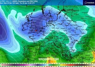
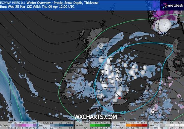
The UK is set to be hit by surprise April snow, with the latest weather maps suggesting bitterly cold weather could strike again next month. WXCharts weather maps, which are prepared using the MetDesk data, suggest snow will spread as far south as London.
The unsettled weather will hit the country at around 12pm on April 9, with 5cm of snow per hour falling in areas around Newcastle. According to the maps, the UK will experience a mix of rain and snow on April 9, with some parts of the country witnessing wet weather. The maps show that areas in Scotland including Dundee, Glasgow, Perth and Edinburgh are likely to see rain, while other major cities such as London, Oxford, Birmingham, Manchester, Leeds and Liverpool could be hit by some snow showers.
Another map also shows a bitter Arctic freeze hovering over all of the UK on April 9, suggesting temperatures could plunge to below freezing in a remarkable shift from the recent warmer weather.
The Met Office's long-range forecast between March 31 and April 9 reads: "High pressure to the southwest of the UK, with weather fronts rounding the high to affect northern parts at times, is likely the dominant patter through this period.
"Wetter and windier weather can be expected in the north, while further south, drier and more settled conditions are more likely. There is a chance of deeper lows moving across the UK at times, bringing wetter and windier weather more widely.
"Later in the period, high pressure may spread across much of the UK leading to more widespread settled conditions. Whilst temperatures will be generally near to or a little above average, some colder interludes are possible, especially in the north, where there could be some wintry showers at times."
Newcastle
York
Carlisle
Manchester
Leeds
Liverpool
Stoke on Trent
London
Southampton
Birmingham
Swansea
Ipswich
Oxford
Gloucester
Contact to : xlf550402@gmail.com
Copyright © boyuanhulian 2020 - 2023. All Right Reserved.