
Britain is bracing for a shock return to winter conditions as WX Charts maps show a 24-hour spell of snow and blizzard conditions sweeping 18 counties across the UK in mid-May. The latest ECMWF weather model charts show bands of snow pushing south across Scotland before spreading into northern England between Tuesday, May 12 and Wednesday, May 13.
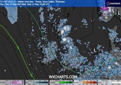
Maps valid from 6pm on Tuesday evening show wintry showers developing across the Highlands and north-east Scotland, with snow intensifying overnight. By 9pm and midnight, heavier outbreaks are shown stretching further south, with parts of Cumbria, Northumberland and County Durham seeing snow showers moving through. Further charts valid at 3am on Wednesday, May 13, continue to show widespread wintry precipitation across Scotland and northern England as low pressure deepens in the North Sea. Snow showers are then forecast to persist into Wednesday afternoon, with maps at 12pm and 3pm showing cold air firmly entrenched across much of Britain.
-Cumbria
-Northumberland
-County Durham
-North Yorkshire
-Lancashire
-West Yorkshire
-South Yorkshire
-Derbyshire
-Greater Manchester
-Cheshire
-Scottish Highlands
-Aberdeenshire
-Perth and Kinross
-Angus
-Moray
-Argyll and Bute
-Stirling
-Inverness-shire
The WX Charts data suggests the most persistent snowfall will be focused over higher ground, particularly across the Scottish Highlands, Grampians and Pennines.
The maps, based on the ECMWF, model show temperatures cold enough for snow across upland areas as bands of precipitation rotate around a low-pressure system.
The first snow showers are shown arriving across northern Scotland by 6pm on Tuesday, May 12, before pushing south-east through the evening.
By midnight, wintry outbreaks are forecast across eastern Scotland and parts of northern England, particularly over higher routes and exposed hills.
Charts valid at 3am on Wednesday continue to show snow showers affecting parts of the Pennines and southern Scotland as the cold pool remains locked in place.
Further maps at 12pm and 3pm on Wednesday, May 13, indicate widespread wintry showers continuing across Britain, although accumulations appear largely confined to elevated areas.
The green 546 dam thickness line shown on the charts - often associated with colder air masses - remains draped across the UK throughout the period.
While lower levels may mainly see cold rain or sleet, the charts indicate temporary snowfall and possible blizzard conditions over hills where showers become heavy and winds strengthen.
Contact to : xlf550402@gmail.com
Copyright © boyuanhulian 2020 - 2023. All Right Reserved.